Interested in Systems/ATUs?
Get Systems/ATUs articles, news and videos right in your inbox! Sign up now.
Systems/ATUs + Get AlertsI have discussed previously how to interpret and use a contour map to assist in a site evaluation to decide where to place an onsite systems. There are times when you will be working on a lot that is not part of a development and the only contour map available are the USGS maps that are not at the scale you need.
There are two ways you can generate a contour map of the lot. Once the contour map is created all the major components of the site can be located on the to-scale map. A designer can use this very accurate information as they design a system that fits the site.
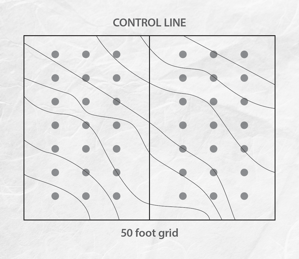
The two ways to establish a contour map are the cross-section method and the trace contour method. To use the cross-section method, set a control or reference line at the center of the lot, then lay out and stake a grid; the elevation is determined at each stake in the grid relative to a benchmark. The distance between points on the grid can vary; but at a scale where 1 inch equals 10 feet a common distance between points is 50 feet. After all the elevations have been determined and the points located on a scaled map, contour lines are drawn based on the desired contour interval using interpolation between points of known elevation.
Interpolation is a method to locate contours using the raw data collected in the field. An advantage of this method is once the raw data are collected the map can be created back in the office rather trying to do this in the field. The information used is the distance between points and the elevations of the points. The proportion of distance and the elevation will be used to locate contours between points.
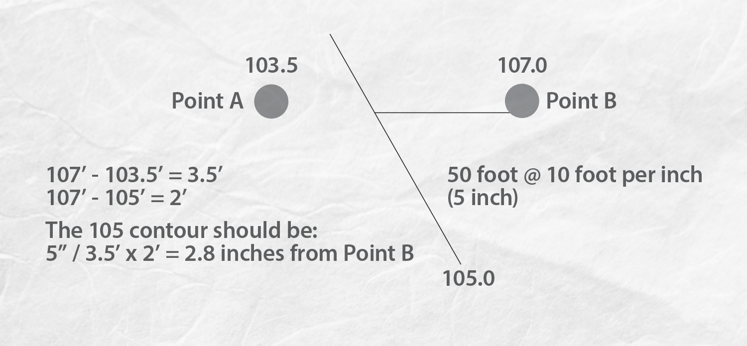
Here is an example. Let’s say I have two points: Point A, elevation 103.5, and Point B, elevation 107; the map scale is 1 inch equals 10 feet and the distance between points is 50 feet. On the to-scale map the distance between points is 5 inches. If I want to locate the contour line at elevation 105 I determine where the line goes between the two points as follows:
107-103.5 = 3.5 feet
107 -105 =2 feet
The 105 contour should be 5 inches ÷ 3.5 feet x 2 feet = 2.8 inches from point B.
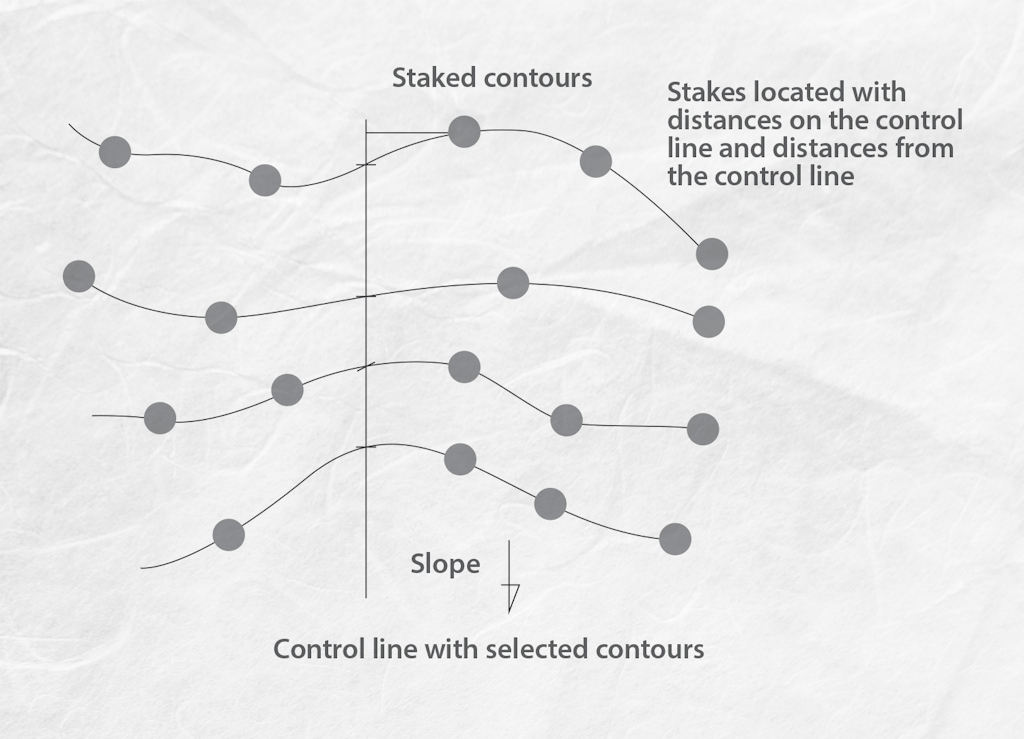
The second method for creating a contour map starts the same way as using a hand-level or other level such as a laser to stake the contour lines on the site at the desired interval. As in the cross-section method, a control in the middle of the lot is established (remember this line is perpendicular to the land slope); locate contours at the set level; stake the contours at a set distance corresponding to the map scale; then locate the stakes on the scale drawing and connect the contours. This method is better suited for those that would rather see contours on the site and use the stakes for construction.
If the site evaluator is passing off the information to a designer a topographic map is key to allow them to properly locate all parts of the system on the map, which can then be used by the installer based on the written specifications.
About the author: Jim Anderson is connected with the University of Minnesota onsite wastewater treatment program and is an emeritus professor in the university’s Department of Soil, Water and Climate. Send him questions about septic system maintenance and operation by sending an email to kim.peterson@colepublishing.com.
This post is part of a series on topography and site mapping:
- Two-Peg Test: How to Determine the Accuracy of Your Leveling Instruments
- Surveying Basics: Reading a Contour Map
- Methods to Make a Contour Map
- Selecting a Site for an Onsite Treatment System