I first want to thank those of you who wrote to me and discussed what you use for design software; your help is much appreciated.
Tim Wilson from British Columbia, Canada, uses CAD. Wilson says that he learned CAD in a six-week night school class. A younger person he was mentoring learned CAD through YouTube videos. Wilson does not think the learning curve is bad for what you get. His list of benefits of using CAD is quite long: He likes that he is using the same software as engineers, developers and builders are using so everything fits together seamlessly. He likes how Word and Excel can import into his CAD documents. He has many prebuilt onsite systems in CAD so design time has dropped considerably for him. As with most software now it’s sold on a subscription basis. He says that CAD LT is less than CA$500 per year. He said what is most important to him is how professional his designs look to his customers.
Frank Aguirre says his learning curve for CAD LT was three months of night classes and he’s been using it for 30 years.
Wayne Johnson mentioned LibreCad which is an open source and very cost-effective option. Johnson says the learning curve is similar to AutoCad LT.
Alan Clapp from North Carolina uses GPS/GNSS Eos Arrow with an iCMTGIS Pro APP on his phone for locating and elevation setting in the field. He uses PC GISX on his computer to import the data collected in the field and can produce PDF drawings from this software. He can “…import shapefiles, Topo, Aerials and CAD drawings into this program for overlays.” He also has ESRI Arcpro and field maps but finds the learning curve steep for these last two. Clapp’s system is extremely similar to what my company is currently transitioning to — more on that later. Brant Bigger from Lake Park, Minnesota, uses a software called Bluebeam. The subscription rates for Bluebeam are quite low compared to others. Bigger included some examples of a completed project in Bluebeam. It appears that what Bluebeam allows one to do is superimpose some basic shapes, text, and lines (solid and dotted) onto GIS images. He said he could not be happier, the learning curve was easy, and the support community works well.

Trapper Davis of Saluda, Virginia, says he’s been using Fast Cad from Evolution Computing since 1995. He says it’s easy to use with a fairly easy learning curve.
In the last article I mentioned landplan.io by New Septic. Carl Preusser of New Septic has been developing this for over 10 years. It is specific to certain states (so far), but wow is it comprehensive. Preusser was kind enough to forward a tutorial video to me, and he has thought of everything. From having over 130 pumps that are cross-referenced when you enter your gpm and TDH, to preplanned system drawings and tank drawings to insert, it then sizes systems for you based on soil test results and the state code. He really hasn’t missed much (if anything). Check to see if he has this finished for your state yet because when he does, this one could be the gold standard (that I’ve seen so far). Preusser has been meticulous about designing a software that uses a state code and your completed soil test, and has everything to complete an extremely thorough plan and specs, including material quantities plus a lot more. This one has the wow factor for what we are discussing here. The only limitation this one has is that it’s not available for every state yet. But the states it is available for, this is definitely worth looking into. It is specific to onsite systems whereas everything mentioned earlier is
general design software.
In our state (Wisconsin), on the Department of Safety and Professional Services website (under POWTS Plan review), they have many pages of templates for all basic inground, mound, at-grade, and holding tank plans. Once you design a system you can just plug the numbers into these prebuilt pages.
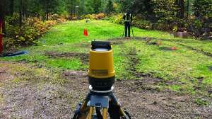
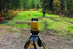
What I’ve decided to try (and I’m just taking it out on my first field try the day I am submitting this article) is very similar to Alan Clapp’s. We purchased a Trimble DA2 GPS/GNSS receiver, iPad and ArcGIS Field Maps software. This is not as much system design as it is soil test help, and a way to generate a design on an overlay. What this allows us to do during soil tests is very accurately locate borings, establish benchmarks and set elevations with the push of a button. Gone will be lasers and measuring locations during soil tests. I learned of this method as several counties we work in have begun to use this exact method (and same tools) for soil tests and system inspections.
During a soil test an inspector located our borings and benchmark while he was on site. By the time we returned to our office our site plan was finished and in our email inbox (and I was sold). The site plan is overlaid on the GIS image to scale. I am doing three soil tests today and using this tool, the soil test site plans will be completed before I return to the office, automatically. The software has enough bells and whistles for me to add whatever adjustments I need to make to a system design to the electronically generated site plan. When I tested this unit, my accuracy (vertical and horizontal) was within less than a half inch. For soil testing alone it will save field time measuring to locate borings and using a laser to set elevations. Not to mention the time in the office it used to take to draw the site plan.
I use county GIS websites every day to look at aerial images and help me develop site plans, but this new method has you right in the GIS in a remarkable way. Future uses of this system I have recently purchased will be on the install crew side and the owner of our company says it will help remarkably when we excavate basements.
This method is pricey. Upfront costs (hardware, software, training) was in the $ 8,500 range. A lot of that was training costs. And the annual subscription is expensive also, at roughly $2,500. The accuracy of locating and generating site plans (for soil tests) in the time it takes me to punch in a boring number makes this system invaluable to me.
I really like the system I went with for generating accurate, fast site plans during soil tests. For actual design software I look forward to the Wisconsin version of landplan.io by New Septic.
These aren’t the only methods, I’m sure there are more. We will keep looking and reporting, and let us know your favorites.
About the author
Todd Stair is vice president of Herr Construction, Inc., with 34 years’ experience designing, installing, repairing, replacing and evaluating septic and mound systems in southeast Wisconsin. He is the author of The Book on Septics and Mounds and a former president of the Wisconsin Onsite Water Recycling Association.
Continue reading for free