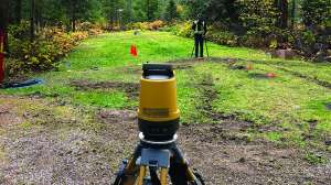
Being from Minnesota and being good “Norwegians,” we have been aware of global positioning systems (GPS) for some time in the context of recreational activities. They are especially useful for when Dave gets lost! However, our main use is locating favorite walleye holes on our favorite lakes.
But now, perhaps your local county is starting to ask for new information for your onsite system plans, and even on your as-builts, when they are submitted. And perhaps it’s really not clear to you why they’re asking or what is happening.
They talk to you about their GIS and how you should buy a GPS, and it is all becoming a pain in your side. So, what are these technologies and why are they now being required for onsite systems? More importantly, are GPS and GIS useful to you as an installer?
Valuable tools
Well, these technologies are tools for creating a clear picture of your county for tracking systems and for future planning. GIS (geographic information system) is a computerized method of storing different types of information, such as the locations of underground facilities, like onsite systems and components.
The first of these systems was put in place for counties to track and record property assessments. From there it moved to community infrastructure, such as streets and sewers and all related items. For some time, water well drillers have been asked to provide GPS coordinates to put well locations into county systems.
A quote from a Web site (www.gis.com) sums it up: “GIS allows us to view, understand, question, interpret and visualize data in many ways that reveal relationships, patterns and trends in the form of maps, globes, reports and charts.”
In more direct English, GIS is a great tool for organizing all the information in the county records — for putting the permit files with the tax records and adding the maps and information together in a single file system.
GIS helps you answer questions and solve problems by looking at your data in a way that is quickly understood and easily shared. Being able to connect all information for a property is a terrific tool for management of onsite systems. GPS, on the other hand, is the technology to get information for the GIS system.
Integrating the system
Another Web site (www.gis development.net) states, “GPS can be thought of as a satellite navi-gation and satellite positioning system, providing signals for geolocation and for the safe and efficient movement, measurement and tracking of people, vehicles and other objects anywhere in the world. It is very reliable, since it is affected neither by the atmospheric conditions, the topography of the ground, nor by the various radio electric interferences.”
GPS is the tool for filling in all the actual ground information the county needs to develop and upgrade its maps. A GPS allows you to gather information that can be input into the county GIS to make the maps better and more accurate. Without a consistent method like this, the system will never be integrated.
How can you use these tools? Well, the first impact is why this question came up. The ability to better track and understand what is happening in the county gives local officials a better way to plan. Use of information from all available sources helps these tools to be more effective.
When you input information about your systems in your county’s GIS database, you help enable better decision making and enable officials to identify areas where there are problems with systems that need to be addressed at the county level. Cooperation between installers and the county can help enable onsite systems and management to be part of the long-term wastewater management solution.
Making life easier
Many engineering reports and designs now incorporate GPS and GIS information. It can be very helpful in determining setbacks from physical features that limit onsite system installation: wetlands, lakes, gullies, drainageways and others.
The technologies also can make the records of your systems easier to use. For example, the tools make it easier for you to return and service the system in the years ahead. They also allow you to quickly create maps and site drawings for service provider visits. Good maps go a long way to minimize the time lost looking for sites or finding the system components once you get there.
Another application of GPS is the ability to track company vehicles. GPS enables you to see where your employees are and allows for easy routing to new work sites.
The technology also can be used to track land application of septage. The ability to track and record this information is a requirement for the 503 regulations. Many of us miss the importance of meeting these requirements as a way to enable long-term use of land application as a tool for onsite system management.
These are only a few of the uses of these tools. Accurate handheld devices are getting less expensive all the time. If you haven’t considered these technologies, now would be a good time to explore their use in your business.
By doing so, at the very least, you’ll become familiar with their uses before they become required. The long-term application of GIS systems will eventually change how all systems are used and regulated. By getting involved early with these technologies, you will get a head start, and in the process become more efficient with your work.
Continue reading for free