Last month in this column we talked about planning and gathering preliminary information from the homeowner and others as a prelude to onsite system installation. This month we move into the field and examine the key issues in evaluating the site to prepare for system design.
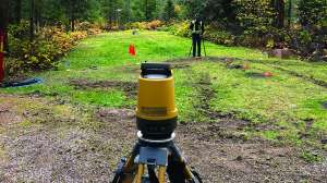
A field-based site evaluation is the only way to determine accurately the conditions present at the site. When possible, all interested parties should meet at the site and discuss what will occur during the evaluation. Here is where the homeowners can detail their specific needs and views.
Knowing the boundaries
Before any soil boring or excavation of soil pits, a call should be made to the state locating system to identify any underground utilities in the area. This generally needs to be done at least 48 hours in advance.
Lot lines should be established to the satisfaction of the owners or their agents. Any lot improvements, required setbacks and easements should be identified and clearly marked. These should have been discovered in the preliminary planning stages, but if there are any questions about exact locations, now is the time to resolve them. These lot surface features should be recorded and located on the site plan map as appropriate:
- The percent and direction of the slope in the area of the system (based on actual measurements and not the contour map referred to last month).
- Vegetation types as they relate to potential limiting soil conditions.
- Any evidence of disturbed soil conditions, such as cut-and-fill or compacted areas.
- A general notation of where on the landscape the system will be located.
- The potential for flooding, ponding or runoff over the area. (This relates to the potential for excess water to collect on the site and interfere with system functions.)
These first observations should help rule out or rule in any sites deemed unsuitable based on the preliminary evaluation that relied on the contour map of the area. In addition, bedrock outcrops, wetlands and other features can be identified.
Checking the soils
The soil treatment part of the system should be installed in original, naturally occurring mineral soil. Original means soil that has not been cut, filled, moved, smeared, compacted or manipulated to the degree that the soil loading rate will be different from natural soil conditions.
Requirements vary from state to state for the number of soil observations that need to be made and the means to obtain the data. Be sure to follow your state requirements. When we are asked how many, our answer (and we are not trying to be funny) is: as many as it takes to adequately evaluate the soil.
If you are in an extremely variable area, it will take more effort to evaluate the soils. In Minnesota, we use soil borings, and at least three are required — but we always recommend at least five to adequately characterize the site.
When we move into other areas of the country, specifically the mountainous areas of the southwest, we move away from hand boring tools and use small excavating equipment to dig small soil pits. Since the soil observations need to be done with tools that maintain the integrity of the soil structure and color characteristics, pits are becoming the norm.
Going deep enough
The depths of borings or excavations also vary according to state code, but they always need to be conducted to below the proposed operating depth to ensure adequate treatment. The proper depth is usually between three and five feet, depending on the code. This means no limiting layer such as saturated soil, bedrock or dense soil occurs within the required depth. The presence of any of these characteristics will affect the depth at which the system can be placed, and other design parameters.
Each soil observation should record several items that can be used in your design or submitted to the designer:
- Depth of each soil horizon.
- Soil color and the presence of soil mottles (if you do not remember these soil characteristics, see our articles in this magazine from September and October 2009).
- Soil texture and consistence.
- Depth to bedrock.
- Depth to periodically saturated soil.
- Depth to standing water.
- Any other characteristics that can affect the design.
In each state code, there is a sizing table or formula that relates the soil sizing factors to the soil texture, structure and consistence. Based on the information listed above, this sizing value can be calculated and used to size the area of the soil treatment system.
Think of the future
The area of the system should be protected from disturbance by way of fencing, staking or some other method. Both the owner and the designer should have a written plan outlining uses and future plans for the property. This is the time to make sure these plans will not affect the primary or alternative drainfield sites. It is easier to move things around now than to scramble to find a new site because of where the owner wants to place some structure or amenity.
Future landscaping plans should be considered to ensure site access for installation and for required operation and maintenance. On newly platted lots, it is a good practice to identify two or more potential sites for a system. Doing this with the property owners on location enables you to show them what is needed for installation and servicing of the system.
That’s a brief rundown of a thorough site evaluation. There is obviously much more detail to address, but this is the framework within which the detail can be added. This year, our goal is to walk through from start to finish what happens with system installation, and the field site evaluation was the second step in that process.
Continue reading for free